- About Us
-
Trips
-
 Kiwi-Style Hiking
-
 Great Walks
-
 Hiking Tours
-
Alpine Hikes
-
Custom Groups
- Huayhuash Trek
- Family Northern Explorer
- Family Southern Explorer
- Lake Waikaremoana Hike
- Women's Custom Tours
- Women's Southern Wilderness
- Coast, Canyons and Mountains
- Coastal Wanderer Custom Tour
- Don't Cross the Ladies
- Secret South Custom Tour
- Tekapo Hike
- West Coast Custom Tour
- World Heritage Custom Tour
-
- Blog
- Shortlist
- About Us
- Trips
- Blog
- Shortlist

Mar 31, 2022
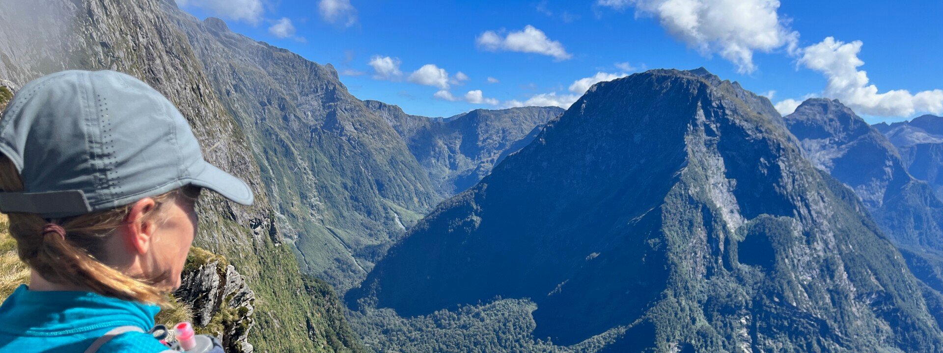
Michelle & Anne rolled their eyes. Claire had called for another summit selfie as the mist had momentarily cleared to reveal a stunning Fiordland backdrop. They later thanked their running buddy for dragging them back the 40m or so as it was truly spectacular. Also, the time pressure was now off, meaning we could bask in those stunning views for a little while longer...

Running the Milford Track in a Day
We had challenged ourselves to run The Milford Track in a day some years ago but life and weather…and Covid, had somewhat derailed every attempt. So as older ‘40 somethings’ we considered this adventure with some trepidation. Our pace has reduced over the last couple of years, but our goals had also changed from one of ‘speed’ to one of ‘experience’. If we continued to train, had a comfortable time goal and contingencies in place, then the only thing stopping us was our heads!
We had delayed our trip one day to Sunday 13th March, due to the promise of ‘Big Yellow’. The ability to be flexible due to weather was a big plus, and most operators are happy to oblige where possible. They want you to be safe and have a good time too.
Logistics and Starting the Milford Track Run
We left our accommodation in Te Anau at 5.30 am to drive to Milford Sound for our 7.30 am boat from Deep Water Basin to Sandfly Point. This was only a quick boat hop, so we were starting our 53.5km journey before 8 am.
Another boat would be waiting for us at the finish for a 6 pm pick up. We had a 10-hour window to complete the run. Darkness was the real issue for both the boat and us. There was a bit of leeway at this time of year but not much.
We should note here that runners are asked to go in the opposite direction to the hikers. We are unsure of the exact reason, but I guess it minimises potential heart attacks from runners sneaking upon them, or it may be to do with the boats? Whatever the reason, north to south suits runners.

From Sandfly Point to Dumpling Hut
The track elevation on paper looked pretty flat for the first 18-20km to Dumpling Hut. And it was. The track was in great condition, with some boardwalk, swing bridges, and pretty river and lake views, making it an enjoyable and relaxed segue way into the mountains. The highlight of this part of the track was the Mackay Falls. We took our time but tried not to stop too much. However, too much coffee, layer removal, and wasp stings all added up. We still managed the first 18km in two hours exactly. Timing was on track.
Climbing Towards Mackinnon Pass
The terrain became steeper after this and went in and out of the bush. Underfoot became a bit rougher in places. There were still some very runnable parts, but you just had to watch your footing. You did need to walk or stop to truly take in the views and avoid a face full of dirt and a broken tooth, and it was well worth doing this. For this very reason, we decided not to take on the side trip to Sutherland Falls (one hour return, running) and instead feel we had the time to stop and enjoy the surroundings for the remainder of the trip. You can see Sutherland Falls from a distance from the main track, so you don’t miss out on one of New Zealand’s largest falls completely.
Waterfalls, Valleys, and Alpine Views
Soon after Quinton Shelter, there were a lot of timber stairs that followed an amazing set of falls along the Roaring Burn River. The water was crystal clear, cascading down different rock formations, some shooting out at speed and others caressing the rock as it spilled over. It was hard to keep going and not be mesmerised by the sights and sounds.
The track opened into a big rocky valley but the trail through it remained obvious and relatively easy to run. Rolling clouds hung about the top of the pass in an otherwise clear blue sky. We kept a good walking pace up the 1000m climb. I don’t recall any particularly steep bits, but I was somewhat distracted by the views.
Boy, what magnificent views they were - ALL the way up! The incredible U-shaped valleys carved by glaciers, tarns, and moraine fields are all a reminder of the power of nature and the beauty it can leave behind. We even witnessed a small avalanche high up over the valley we were just in, demonstrating why there is an alternative route when the avalanche risk is higher.
As we continued our climb, the groups heading down were bundled up like Eskimos, exclaiming how cold it was on the top and that there was no view as the cloud would not budge. I don’t doubt for a second that it was that cold, things can change rapidly in the mountains, but by the time we reached the top we only needed a thermal layer, and the cloud was clearing nicely.

Sharing the Track with Hikers
Groups of hikers all seemed intrigued by a group of runners travelling the ‘wrong way’. If we had had a dollar for every group heading down that told us that we were going the wrong way we would have been able to afford a triple scoop of real fruit ice cream - each! We were mindful of being respectful to those hiking and had a joke or conversation with many of them. We were all out there for the experience and enjoyment.
Spectacular Views from Mackinnon Pass
So back to the selfie…..after a quick stop at MacKinnon Pass Shelter around 1 pm, the mountain tops still had not revealed themselves completely so we decided we had to keep moving and went on our way. However, you had to stop every now and again on the tops and keep looking back so that you didn’t miss big chunks of the scenery because you were running it……. A glance back and as if on cue the clouds lifted to reveal a magical mountain vista. So, back we went! Some hazy clouds stubbornly remained to give it that mystical feeling, but you could see the mountainous horizon for 360 degrees, and it was amazing.

Descending to the Eastern Valleys
We had five hours left to complete the run and any doubt we couldn’t get back by 6 pm was gone. The run down towards Mintaro Hut was done a bit more carefully than we would have if we had time pressure. From now on we pretty much ‘joggled’ it (ran some, jogged some, walked some). The views were awesome, and we could soak them in. It took about an hour to get to the bottom of the steeper downhill. We then had 4 hours to cover the last 22.3km and get to the boat – easy! Or maybe not.
After a gentle downhill, we were back in the bush. Dappled light on a sunny day can make navigating an uneven track a bit more difficult when running ….I never go over on my ankle but did it twice in quick succession, the second stopping me in my tracks. A strong anti-inflammatory and a half-hour of hobbling later was enough to allow a very ginger run. Yes, we were well on schedule, but we had to keep moving.
Running Along the Clinton River
The boulder-strewn river close to the ‘Bus Shelter’, which must be a spectacle in high waters, showcased a continuous giant wall of rocky waterfalls typical of the Milford region but always spectacular. Another reminder to keep looking around, even if you must stop running.
The track followed the Clinton River and its tributaries. It was so clear that often you couldn’t see the water over the rocks, other times it was tinged a vivid green or blue. It was also delicious! Being such a hot day, we had no excuses to make the most of this Fiordland treasure. Oh, and the birdsong……it was hard to miss on this side of Mackinnon Pass.

The Final Stretch to the Finish
The last two hours were a bit of a blur. The track continued along the river in the bush. The terrain was pretty consistent, unlike the three of us! One had to walk (but could walk fast), one had to run (but could go slower by doing the soldier shuffle), one couldn’t stop – but all trying to stick together. Three forty-somethings cracking up at themselves but in great spirits, as we had had a magic experience and were close to knocking the Ba#@tard off.
The last couple of K’s were along a wide track to the boat and we made it with 15 minutes to spare! A quick selfie next to the Milford Track sign and onto the boat. The skipper was more than accommodating. He allowed us to jump in the lake to cool off before changing into dry clothes that we had dropped at their base the day before. He then brought our beers out and had even put them in the fridge earlier in the day and refrozen our ice packs! What a legend!
Celebrating at the Finish Line
Cold beer, chips, and a dip (ourselves, not cheese) followed by an hour’s boat ride back to Te Anau Downs where our car was waiting for us after being relocated – what a fantastic end to a bucket list day!

Milford Track Run Timing and Splits:
2 Hours to Dumpling Hut from Sandfly Point Shelter - Running
5 Hours to MacKinnon Pass from Sandfly Point Shelter - Mixture Run/Walk
10 Hours to Glade Wharf from Sandfly Point Shelter - Mixture Run/Walk
How We Organised Transport and Boats:
Booked a same day car relocation from Milford Sound back to Te Anau Downs
Charter Boat – 7.30am - Milford Sound (Deep Water Basin) to Sandfly Point Shelter (10 mins)
Charter Boat – 6.00pm - Glade Wharf to Te Anau Downs (1hr)
Accommodation – We stayed in Te Anau the night before and the night after
We used Fiordland Outdoors Company for the boat transfers at each end
Tips for Running the Milford Track:
Plenty of water to drink – huts and rivers
Weather can change in an instant – take warm gear even if hot
We didn’t bother taking insect repellent with us (maybe pop some into dry clothes bag for the end at Glade Wharf)
Poles – we all had one pole each and just ran with it when running. Helped on the hill but totally personal preference.
First aid kit – ensure includes antihistamines (wasps), anti-inflammatories you can stomach (take with food), and painkillers (easy to roll an ankle or trip).
PLB (we carried two between us) – always necessary when in the backcountry – the ankle injury or wasp reaction could have been worse. With at least 2-3 hours running between huts you can’t rely on these for emergencies.

